Back in the days when my kids were in school it always seemed like summer was over by the end of August. I constantly had to remind myself that once September hit, there were still three more official weeks of summer, and these weeks can often bring the most glorious weather. Several of our Shoreline towns offer great combinations of nearby places to go to experience both the seashore and the forest to soak up a little bit of everything in a single visit and make the most of those late summer days. In this post, I focus on Guilford. All of these destinations can be visited singly – but for maximum enjoyment I recommend a two-for-one scenario!
CHAFFINCH ISLAND PARK, Guilford
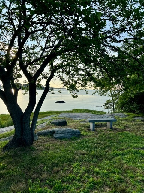
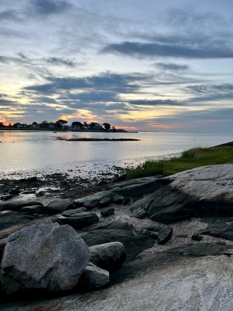
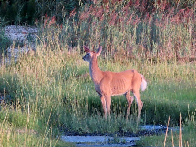
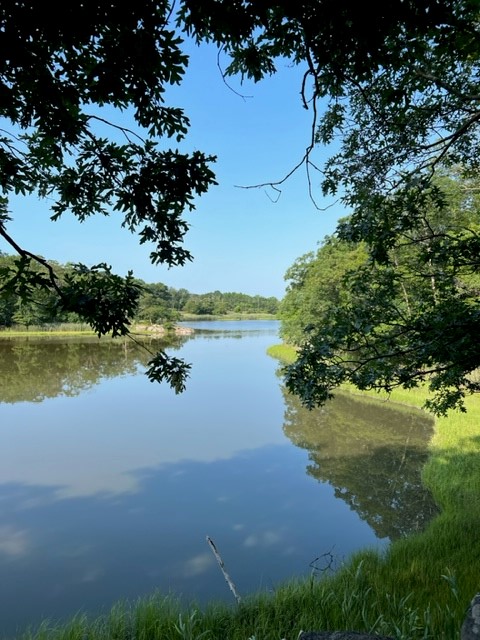
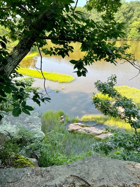
This 22-acre park is truly a hidden gem. I first visited on a gorgeous day in mid-July just before 6:30am. On Google the hours are listed as 6:00am to 8:00pm. There is a gate, but whether or not a town employee comes to open and close it every day I have no idea. The topography of this spit of land is lovely – with rocky outcroppings to the east and south where you can linger to admire the view (it isn’t truly an island). To the east there is a view to the West River as it empties into Long Island Sound. From the southern tip you can see the lighthouse on Faulkner’s Island in the distance. There are numerous well-maintained picnic tables and grills scattered around the property, including one nestled under what I believe is an enormous basswood tree. The flowers were past their prime, but the bees hadn’t given up yet and were humming all over. As I made my way back there was a bunny in the grass that darted away on my approach. I returned in late August for sunrise and had an unexpected encounter with a deer (read my tale below). At the time of my visit there was a port-a-potty and several trash bins in the parking lot. There is a wheelchair accessible path to a picnic table along the river. While listed on the Guilford Parks & Rec website, there is very little information about this park. It was a delightful spot to observe a pre-hike sunrise and I imagine it would also make a wonderful post-hike picnic or sunset destination.
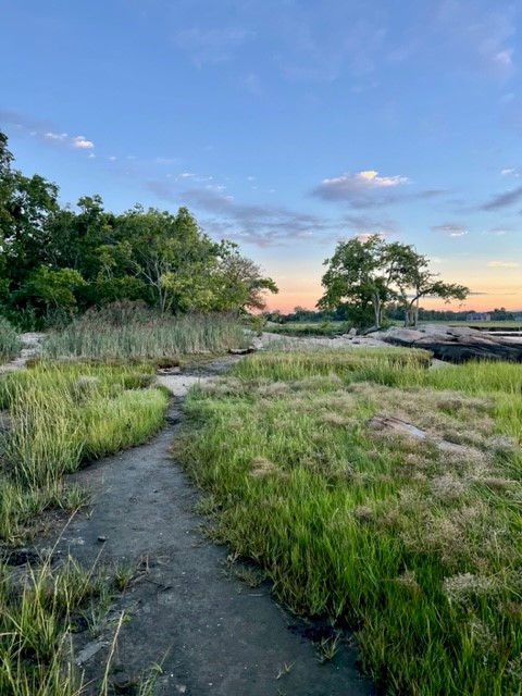
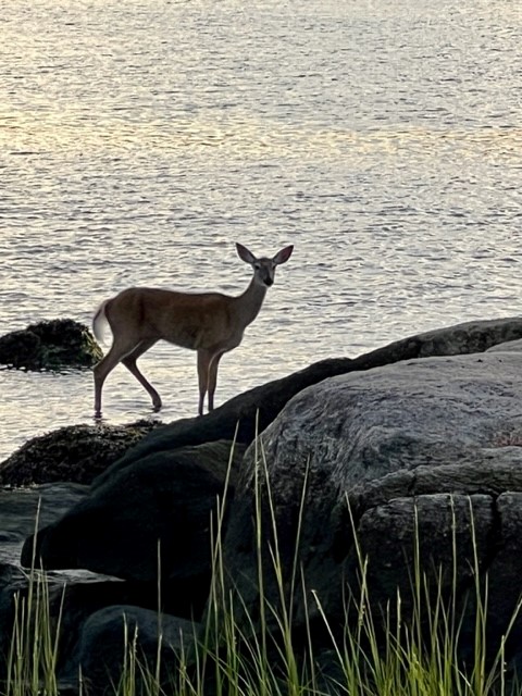
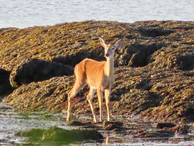
It was low tide when I arrived for sunrise in late August, so I made my way along the muddy path to a cluster of rocks accessible off the end of the point, coffee cup and my handheld Canon in hand. As I faced west taking some pictures of the egrets and seagulls, I heard a commotion behind me. Turning, I saw a doe bounding along the same path I had taken moments before. I believe a dog had startled her. For a short while she did not notice me, as all her attention was directed at the perceived threat along the shore. I toggled between my canon and my phone camera taking numerous videos and photos. Then she saw me. From that moment on, all her attention was directed towards me and we were in a stand-off.

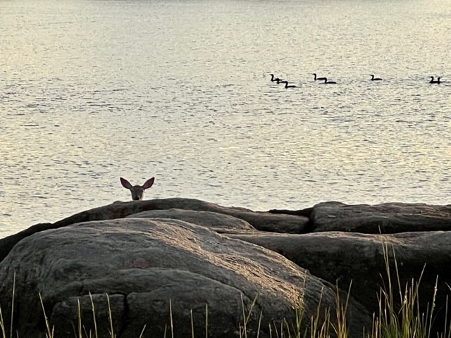
I gave in first, rising slowly and making my way back to shore. I looped around and snuck back out onto the point to watch her journey. She had walked around the cluster of rocks and was heading through the shallow water of the bay. When I arose early that morning my hope was to get a few nice sunrise shots for my blog post. The serendipity of my interaction with this deer reminded me that we never know what we may encounter on any given day, and that the most important thing is to get out there and surprise ourselves.

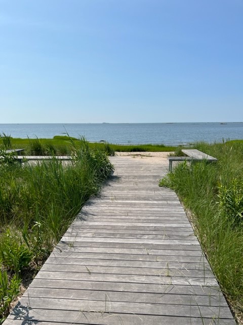
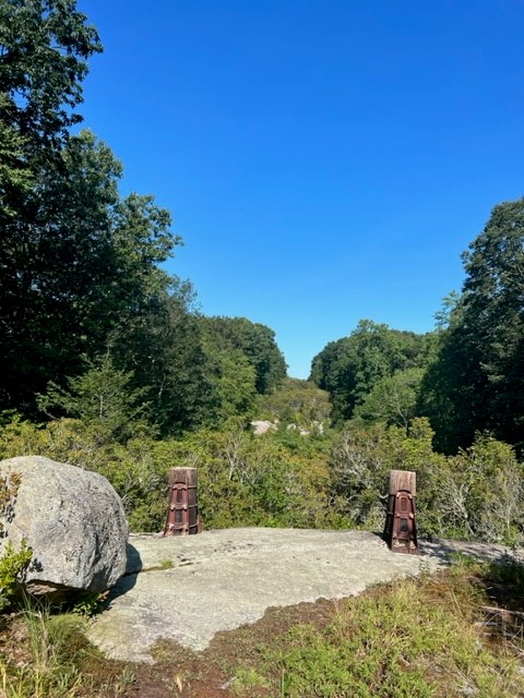
CHITTENDEN PARK, Guilford
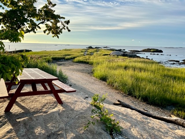
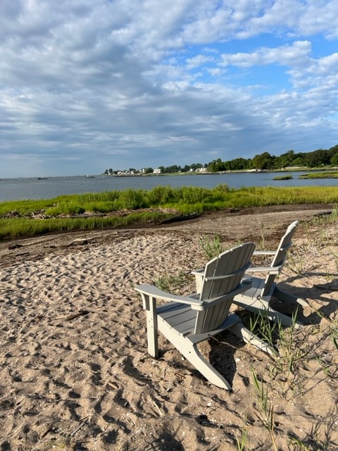
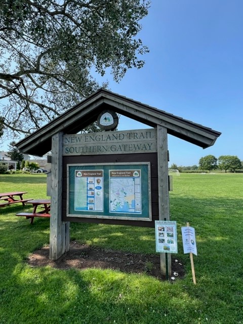
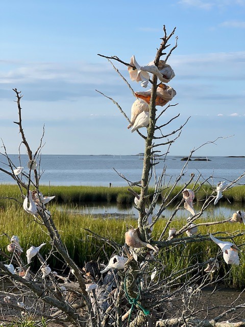
The boardwalk at Chittenden Park is the southern terminus of The New England Trail, a 215 mile hiking trail that goes from Long Island Sound through Connecticut and Massachusetts to the NH border. This section of trail is referred to as NET Trail – Section 5. For more information about the NET click HERE. Personally, I don’t care for trail sections that go along roadways as most of this section does, so I can’t tell you anything about this section beyond saying that Chittenden Park itself is definitely worth a visit. From the parking lot, cross the soccer field and you will see a boardwalk that leads to a sitting area with views of Long Island Sound. You can walk along the curve of sand to the right and enjoy the sights and sounds of the cove, with views to Chaffinch Island Park and Faulkner’s Island. There are two Adirondack chairs set above the high tide line where you can sit and enjoy the view. I recommend visiting at or near low tide so that you can stroll further down the beach through the reeds and seasonal blooms. On September 1 low tide will be at 6:24AM and 6:50PM. Click HERE for a tide chart for Guilford. At one point there is a driftwood tree decorated with seashells, and you can observe 3 different osprey nests in the area. A restoration project is underway and on my most recent visit much of the area behind the soccer field was dug up and protected by orange plastic fencing. There is a break in the fencing that allows passage to the boardwalk.
WESTWOODS, Guilford
The Westwoods parcel in Guilford offers an astonishing array of hiking trails in varied lengths and difficulties. For decades my main relationship with these trails was as part of our Thanksgiving ritual – the lovingly named “Forced March” – before reconvening at my mother-in-law’s house in Guilford for the annual Thanksgiving dinner. I have only recently started to explore these trails on my own.
According to the Guilford Land Conservation Trust (GLCT) website, the first 7 miles of trails were blazed in 1966, and since then the property has expanded to over 39 miles of trails on 1,200 acres. All the trails are maintained by the Westwoods Trails Committee of the GLCT and are on land owned by different entities including the Land Trust, the Town of Guilford, the State of Connecticut and private parties. Descriptions of each trail can be found HERE and parking information and a trail map can be found HERE.
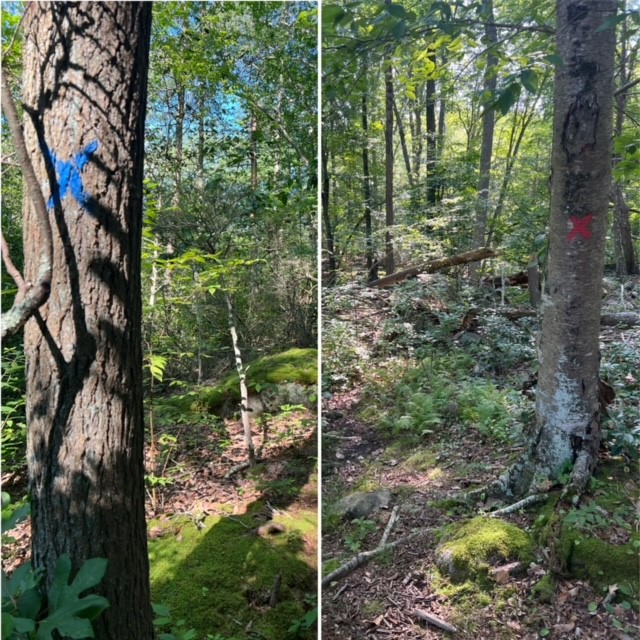
In general, I have found the trails to be well marked. The challenge, especially if you are new to hiking, is that there are SO MANY trails and offshoot trails it can get confusing. I found it helpful to use a downloaded AllTrails map to help ensure I was going in generally the correct direction, however it is helpful to also have the GLCT map available so you can see the blaze colors and shapes, as AllTrails does NOT differentiate blaze colors or shapes. You also want to make sure you stay on blazed trails and not wander off onto unmarked trails. The Trails Committee is working hard to spread the word about the importance of staying on marked trails, including the use of “THIS IS NOT A TRAIL” signs in places where it can be confusing, as this is causing a lot of environmental damage.
Following are suggestions for two easy to moderate hikes. In addition, the GLCT lists 15 different suggested hikes on their website with detailed narratives. For more information click HERE.
BLUE/RED/GREEN LOOP. 3.6 miles. We parked at the Dunk Rock Road trailhead and followed the blue circle trail to start. At the intersection with the red square trail we turned left to hike a loop. Instead if completing the full loop, we found a cross trail to get back to the blue circle trail. This cross trail does NOT show up on the online map. Cross trails are marked with X’s in the color of the trail to which you are headed. In other words, the same trail had blue X’s in the direction that led to the blue trail and red X’s in the opposite direction. We then followed blue circles until we connected with green circles to loop back to our car. We took full advantage of both the paper map and the GPS map to make sure we were headed in the right direction. We particularly liked the impressive rock formations along the green circle trail.

WHITE LOST LAKE LOOP. 3.2 miles. I parked at the Sam Hill Trailhead and followed the white circle trail, doing a counterclockwise lollipop loop of white square to white circle. The white square trail goes along Lost Lake and there are several scenic viewpoints along the way. When I reached the northern end of the lake I took a short detour onto the yellow circle trail to check out Lost Lake Falls where the stream enters the lake. This trail went very steeply downhill, and I later read online that the yellow circle trail is one of the most difficult in Westwoods and is recommended only for experienced hikers. I will come back another day and try it when I have my hiking poles with me.
Subscribe to Trail Talk
your next adventure awaits
Questions? Email me at naturenerdsramble@gmail.com or find me on Instagram @the_real_nature_renee.
